Last weekend we were gulping water and gasping for air. This weekend wasn't much different, well, except we were using our arms more then our legs. Oh, and I took zero pictures (on my camera). Known for it's world-class white water rafting, Ryan and I headed out to Boise for a half day white water rafting trip down the South Fork of the Payette River. The eight mile section of river contained exhilarating Class III-IV rapids with names like Bronco Billy, Staircase and Slalom (I'll let you use your imagination to figure out how they got named). Despite our novice attempts and knocking heads, the only time we got dunked was after a fun 20 foot jump off an overhanging rock. You've probably figured out why I didn't bring my camera along, so if you're interested, you can check out this link: http://www.cascaderaftphotos.com/ (Click on South Fork, 8-29-09, AM, Pictures 1-7, 15-19 and 30-35.) Oh, and if you happen to order any photos... just let me know!!
After last weeks hike, I realized I didn't have many people in my pictures. So after swapping pictures around, here's a few more with the rest of the group:
The bright and cheery group at 7:30 (and prior to any hiking). L-to-R: Joe, Ryan, Tyler, Miken, Keri, Jeff, Jamie, Brandon, Chris, Marnie, Eric
Eric takes my kind of picture - the kind where you're in it, but no one can tell it's you...
...well, until you jump.
Looking up the trail at Chicken Out Ridge.
Good thing it wasn't windy! Oh wait...
This must be where we discussed how "crazy" is a relative term.
Jamie and Brandon before parting ways (temporarily).
Finally at the top!
L-to-R: Joe, Chris (aka John), Miken, Ryan, Jeff, Keri, Marnie, Tyler, Eric and Brandon.
One more summer weekend left, so you'll have to stop back to see what it brings!
Monday, August 31, 2009
Sunday, August 23, 2009
Topping Idaho - Borah Peak
Some of you have been wondering what kind of a doosy this weekend would bring. Rather then go into a long description, I'll list a few highlights and those interested can get the full description at websites like http://www.summitpost.org/mountain/rock/150190/borah-peak.html or Google search "Borah Peak Idaho". Here's the quick list:
Round Trip: ~7 miles
Elevation Gain: ~5,500 feet (For those good at math, you can figure out the average grade. For those who aren't, it's ~30%.)
Highest Point: 12,662 feet (tallest in Idaho)
Hiking Time: 6 - 12 hours, scrambling required
Number of Fatalities: What are you, crazy? I can't tell you that - my Mom reads this thing.
Friday night we camped at the base of Borah Peak and these were the views as the sunset shone on Chicken Out Ridge (background, right) and Borah Peak (background, center).
The Wieschhaus' watching the sun set. After a fire, Catch Phrase, some quick sleep and oatmeal, we were off. There were 11 of us either brave enough, stupid enough or just ignorant enough to head out. I'll have to post a group picture to indict the rest of the crew once I get it.
Chris pretends like the first mile wasn't so strenuous. OK, so he wasn't tired, and yes, he was the oldest in our group.
I don't remember the elevation at this point, but here's a view looking back. As you go through the rest of the pictures, you'll recognize the parking lot and campground. I also circled the barren "hill" with 3 little trees on top that seemed so high the night before.
Standing at the same spot and looking up, you can see from Chicken Out Ridge to the top. There's probably a mile of hiking that's out of view on the right as the sun washes out the view of the mountain.
Eric gets a picture from the ridge we were walking along.
A colorful peak across from Borah on our way up.
Up a little further you can see the final trail leading to Chicken Out Ridge on the right. You'll see the snowfield that starts in the middle of the saddle again. Later pictures make crossing the snow look easy, so keep this one on mind.
More views to the South.
How come none of the trail descriptions recommend gloves for rock climbing? Maybe next time...
Looking back at the ridge where the pictures with the red lines were taken. That's the ridge Eric was standing on in a previous picture and if you click on it, you'll see people on the trail. All I know is that our legs informed us that it's not as flat as it looks!
Getting closer to the peak!
More amazing views on the way up.
Looking back at the ridge and road to the campsite.
More amazing views on the way up.
Looking back at the ridge and road to the campsite.
I'm not sure if the glare is from the sun or Chris as he takes the high route over Chicken Out Ridge. Marny starts out on the lower route. You can barely see the snow field in the middle of the picture.
A picture after crossing the snow field on the low route. Soon after taking this picture, while waiting for the rest of the crew to cross Chicken Out Ridge, I heard a sliding noise followed by "Mark!!! Mark!!! Maaaarrrrkkkk!!!" as a man tempted fate by walking across the snow field where there was no trail. Fortunately, he was able to grab a rock as he floundered and broke his slide. If he hadn't stopped there or at the trail, the ending to this story would have been different considering the next stopping point was a few thousand feet lower in elevation.
Hikers climbing up and down the nose at the top of the snow field.
What are flowers doing at 11,000 feet?
After crossing the ridge, we got a better view of the rest of the hike. If you look close, you can see the trail leading to the top.
Views off the East face, including a little lake at the bottom.
Chris doesn't understand why you can't take a picture here and pretend it's the top.
Eric wins King of the Mountain, but where is Joe?
Views off the East face, including a little lake at the bottom.
Chris doesn't understand why you can't take a picture here and pretend it's the top.
Eric wins King of the Mountain, but where is Joe?
Phew - still keeping up.
Team RPCO (Eric, Chris, Ryan, Brandon, Joe; Not pictured - Jamie) at 12,662 feet. Brandon is clearly the tallest point in Idaho...
...but not to be out done, Eric gives it a jump...
...and he doesn't just jump. Nope, he does it with a rope! (And you all thought I was crazy.)
The Lewis brothers (Ryan and Tyler) with their shirts on and not kicking up a dust storm.
Enough with the short jokes, cause that right foot is currently the tallest thing in Idaho at about 12,668 feet.
Another look back at the ridge and road to the campsite, more then a mile below us in elevation.
Jamie leads the pack from the peak.
Another look back at the ridge and road to the campsite, more then a mile below us in elevation.
Jamie leads the pack from the peak.
View on the way down. Despite the clear blue sky on the way up, it snowed on top and we did compete for space with two lightening bolts as the sporadic rain clouds moved in.
Simply amazing!
Since none of us had done this hike, we weren't sure what to expect. But we all made it alive and even enjoyed, well, at least the view! And, I suppose after a few days we might even forget about the sore muscles, aching joints, cuts and bruises as we all took a few spills and attempted some acrobatic maneuvers sliding down the rocks.
The real question is this... how am I going to top that next weekend??? Hmmm....
Sunday, August 16, 2009
Parking
This past week I came across a simple recipe for success. But similar to the biscuits and gravy that I continue to try and make, it takes more then a recipe. How hard can it be to make gravy out of fried sausage, flour and milk? Too thick, too thin, tastes like flour, tastes like milk... how can combining two ingredients be so difficult? While I try to figure that one out, let me at least share my recipe for a successful life:
1. Always be joyful
2. Pray continually
3. Give thanks regardless of circumstances
4. Don't quench the Holy Spirit
5. Listen to your preacher
6. Prove everything, keeping only the good
7. Avoid all evil, including the appearance of evil
8. Live totally consecrated to God
9. Believe God to deliver His promises
For those who don't recognize this list, it's in 1 Thessalonians 5:16-24, but that's only the recipe. Lord, help me to daily live by Your recipe for success!
This week has been full of excitement - work was exciting, meetings were exciting and weekends are always exciting. Saturday I headed out to Yellowstone to try some new trails and hit some of my favorite spots at the Park. I was secretly hoping I might even catch a glimpse of Obama and his entourage, but he didn't stick around and his wheels must be a lot faster then mine because he got from Montana to Arizona in just a few hours! So, no pictures of the President, but I dare say that some of these pictures might take your breath away anyways.
An eerie start to the morning as steam from the thermal hot springs rises between the trees.
A little murky, but at 200 degrees Fahrenheit, I wasn't about to jump in anyways.
Flowers and falls. Still trying to figure out how to get both in focus.
Boiling water.
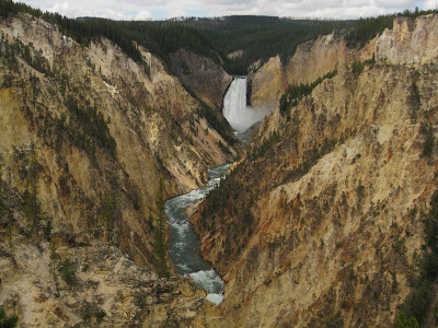
The Grand Canyon of Yellowstone. I hope you don't mind a bunch of pictures of the same place (nobodies complained about too many pictures yet). I think you'll quickly see why this is one of my favorite Yellowstone destinations. The first few pictures were taken from the North Rim Lower Falls trail.
I promise this is a real place!
Taken at the end of the trail, 3 feet above the lower falls (hence the rising mist). Click on the picture if you want to feel like you're in the canyon!
Further down the North Rim trail at Grand View.
It looks more like a painting, but they called this one Inspiration Point. If you look off into the distance, near the top, you can see Lower Falls.
Same view as I play with some of the camera settings.
Upper Falls as I head towards the South Rim trail. If you need some perspective and look really close, there's people to the right of the falls at an overlook.
Looking at Lower Falls from Uncle Tom's trail. Once again, look close on the right side of the falls and you'll see people. That's also where I took the first few pictures with mist in the foreground. (So if you could see where the water runs, you would be looking down the vast canyon expanse seen in the previous pictures!)
It looks more like a painting, which is probably why they called it Artist Point.
A slightly different view.
Looking the other direction at Artist Point. I love all the different colors in the canyon walls.
This picture isn't doing any view or anybody justice... next time it's back to the handstands.
From Yellowstone, I hurried (at 5 mph behind a few mobile monster homes) down to Grand Teton National Park. Despite the clouds and impending storm, I still love the magnificent, spectacular, awe inspiring Teton Range. Here's a few more pictures if you don't believe me!
Click for a better view as this is a couple of pictures merged together.
And this isn't even the grandest of them all!
Clouds and rain obscure the peaks... but what can keep you from God's love? (Nothing)
The view from Oxbow Bend.
Last time I was here the sun was casting beautiful reflections off the water. This time the beauty is in the storm clouds rolling over the mountains...
... as the wind makes ripples in the water.
A moose drinking at Oxbow bend? He must be lost.
The sun shinin' through.
I love how the clouds are rolling off the mountain - makes it look like the mountain is smoking.
The light shines through the clouds and across Jenny Lake.
The view from Mormon Row.
Zoom zoom zoom... (I don't have a Nissan but some of you might understand how that fits into my trips through the Parks!)
And there you have it, another weekend travelled! If the weather cooperates, you may want to stop back after next weekends adventure! It's likely to be a doosy:)
Subscribe to:
Posts (Atom)